
Hurricane Erin Weakens to Category 3, But Dangers Persist Across Caribbean o
Hurricane Erin: A Rare Category 5 Over the Weekend
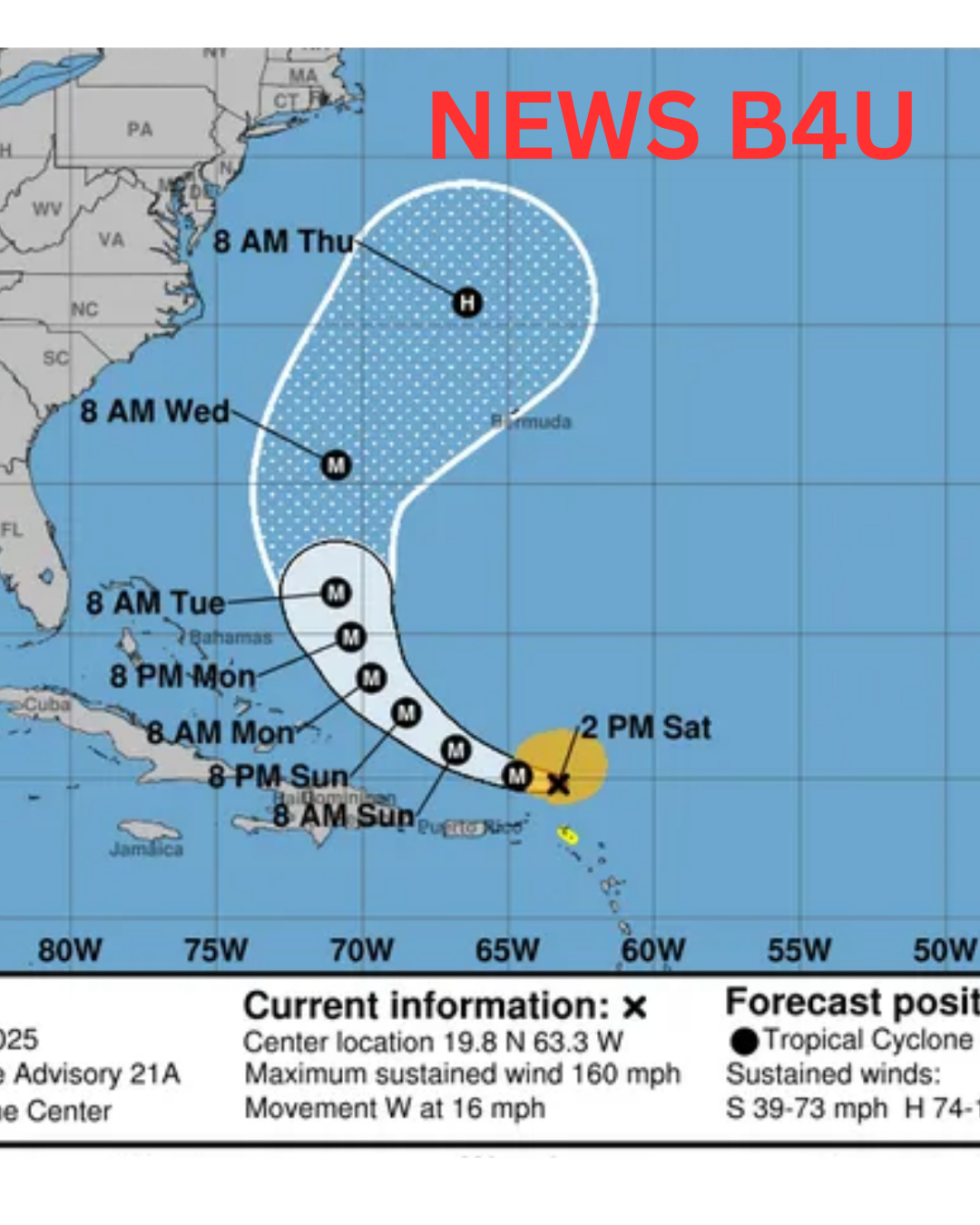
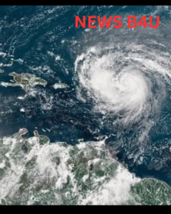
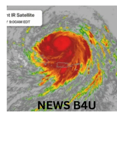
Erin shocked meteorologists on Saturday night when it quickly intensified into a Category 5 hurricane. Winds surged to 160 mph (260 km/h) in just hours. This rapid intensification caught many off guard.
According to Mike Brennan, director of the National Hurricane Center (NHC), Erin “explosively deepened and intensified” as it charged through warm ocean waters. It grew from a tropical storm into one of the season’s most powerful storms in under 24 hours.
Storm Is Now Turning Northward
The good news? Erin is turning northward, away from the heart of the Caribbean and the mainland United States. The NHC forecasts that the storm will continue moving northeast, pushing back into the Atlantic by midweek.
But that doesn’t mean the danger is over.
Erin Is Growing in Size
Though it has weakened in wind strength, Erin is expanding in size. The storm now stretches over 205 miles from its center with hurricane-force winds reaching up to 25 miles out. That means more areas are at risk, even if they’re far from the eye.
The storm’s reach is so wide that it is generating hazardous conditions across multiple island chains.
Flash Flooding and Landslides Expected
The Virgin Islands, Puerto Rico, and parts of the Bahamian Archipelago are bracing for heavy rain, flash floods, and possible landslides. The NHC has issued warnings for these regions.
Rainfall totals could reach 6 inches (15 cm) in the Turks and Caicos Islands and the US Virgin Islands. That much rain in a short period can cause rivers to overflow and hillsides to give way.
Tropical Storm Warnings Issued
Tropical storm warnings remain in place for:
Turks and Caicos Islands
Parts of the Bahamas
St Thomas and St John in the US Virgin Islands
The US Coast Guard has restricted vessel movements in six Puerto Rican municipalities, including San Juan. Gale-force winds and high waves are making sea travel dangerous.
Dangerous Surf Expected Along the US East Coast
Even though Erin may not make landfall in the mainland US, the storm is generating powerful ocean swells. These waves will reach almost the entire US East Coast over the coming days.
Florida and the Mid-Atlantic states should prepare for life-threatening rip currents and dangerous surf conditions. Beaches may look calm, but strong undercurrents can quickly pull swimmers out to sea.
Bermuda is also under threat, with heavy rainfall and large waves expected early next week.
Global Warming and Stronger Storms
This year’s Atlantic hurricane season was already forecast to be “above normal,” according to the National Oceanic and Atmospheric Administration (NOAA). Erin’s explosive growth highlights the growing trend of more intense hurricanes.
Warm ocean temperatures, driven by climate change, fuel these storms. As global temperatures rise, the number of Category 4 and 5 hurricanes is expected to increase.
What’s Next for Erin?
Erin will likely fluctuate in strength as it continues its path northeast. While no direct US landfall is expected, residents along the East Coast and in Caribbean nations should remain alert.
The storm’s large wind field means hazardous conditions can strike far from the center. Flash floods, landslides, and dangerous surf will continue to threaten lives and property in the coming days.
Stay Safe and Stay Informed
Residents in affected areas should:
Follow local weather advisories
Avoid swimming or boating
Stay indoors during heavy rain
Prepare for possible power outages and flooding
The 2025 Atlantic hurricane season is just getting started. Erin is the first named hurricane this year—and it has already made a major impact.
As the season continues, experts urge everyone in hurricane-prone areas to have a storm plan ready and supplies on hand. Early action saves lives.